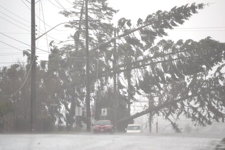
Last week’s intense windstorm had all the characteristics of a “decent hurricane,” according to a UBC PhD candidate studying B.C.’s windstorms.
The deep, low pressure system on March 12 brought with it wind conditions reminiscent of one of the rare hurricanes to ever hit the B.C. south coast, says Wolf Read, a PhD candidate in Forest Science at UBC.
“Last week’s vicious windstorm was a gale on par with hurricane Freda – aka The Columbus Day storm – in 1962 which was one of the most destructive windstorms in the history of southwest B.C.,” according to Read, who has been working on his PhD on windstorms in B.C. and was able to put the March 12 storm into the context of past windstorms in B.C. He was also able to explain why last week’s storm was so strong.
“When a Pacific storm strikes, the strength of measured surface winds at a particular location are related to a number of factors,” he says.
The March 12 cyclone (picture those satellite images of spiraling cloud formations you see in hurricane weather reports) had great intensity, Read says. It had a very low barometric pressure at the centre – 96.1 kPa (28.38”). When an extratropical cyclone like the March 12 storm has a very low pressure, it is called “deep,” he says. The deeper the low, relative to the surrounding pressure, the greater the likelihood of intense winds. The March 12 storm had strong differences in atmospheric pressure within a few hundred kilometres of the centre.
The difference in pressure between stations is called the pressure gradient. Gradients in pressure drive the winds.
Another key factor in the storm is that the centre passed right over Solander Island off the Brooks Peninsula and therefore relatively close to Campbell River. The closer a low passes to a region, the more likely that location will experience damaging winds.
Read examined the pressure data from key stations on northern Vancouver Island: Estevan Point, Solander Island and Port Hardy and calculated the pressure gradients for the March 12 storm.
“The results are phenomenal,” he says.
The pressure gradient peaked at 18.3 hPa per 100 km at 9 a.m. on March 12 – around the time of peak winds at Campbell River, Read says. To put these numbers into perspective, he relates them to several intense windstorms that have struck southwest B.C. – including, for example, the Dec. 2006 storm that caused widespread destruction to trees in Vancouver’s Stanley Park – and none of these produced a gradient as high as on March 12 on Vancouver Island.
Few major windstorms produce gradients above 12 hPa per 100 km. and values down in the 4.5-6.0 hPa-per-100-km. range can result in fairly strong winds, Read says. Remember, the March 12 reading was 18.3 hPa.
The pressure gradient within about 100-150 km. of the centre of the March 12 storm “appears to to have been comparable to a decent hurricane,” Read says. In fact, he says, they were reminiscent of Freda.
Typhoon Freda – or the remnants of Freda – struck the Pacific coast in 1962 and caused an estimated $10 million in damages and seven deaths, according to Natural Resources Canada’s website. Winds were recorded in Victoria reaching sustained speeds of 74 km/h with gusts to 145 km/h.
Campbell River, of course, had reports of 134-km/h winds. And Read points out that the equipment we have today is better, more accurate.
In addition to the pressure gradient, the March 12 storm was given a further boost by the fact that it tracked NNE to N as it passed Campbell River. The storm’s motion coming out of the SSE/SE can enhance wind speed giving it a boost of about 25 km/h, Read says. The cyclone also reached the north coast of Vancouver Island at or near peak intensity. More often, lows are mature and dying when they reach Vancouver Island, Read says. These fading lows can still produce a decent windstorm.
However, a peak intensity storm is more likely to have the gradients and dynamics to produce damaging winds.