Don’t worry if you’ve never heard of the North Vancouver Island Marine Plan, you’re probably not alone.
But you’d better get up to speed on it quickly because the plan is due to be finalized in about two months.
“We’re anticipating that the plan will be completed in June of this year,” said Matthew Justice, a senior marine specialist with the provincial government and co-host of an information meeting on the plan held Monday at the Maritime Heritage Centre.
Some of the 20-30 people attending the meeting complained about a lack of prior notice about it.
Justice apologized for that saying they were “running around like chickens with their heads cut off” which hindered them in getting the word out.
Well, it doesn’t look like they’re going to have much time in the next couple of months, either, because the process is drawing to a close. It’s already at the public consultation stage and there are only five weeks left for the public to provide input.
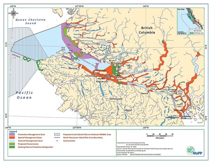
So, what’s it all about? Basically, it’s a zoning plan that will provide direction to the provincial government in managing marine resources that it has jurisdiction over. It is part of the broader First Nations-BC Marine Planning Partnership (MaPP) initiative and is one of four marine plans being developed for the north coast of British Columbia. The other three are Haida Gwaii, North Coast and Central Coast.
The MaPP initiative is a partnership between 18 First Nations and the Province of British Columbia that is planning for marine uses and the long-term health of B.C.’s North Pacific coast.
According to MaPP documents, “The purpose of the North Vancouver Island (NVI) Marine Plan is to provide recommendations for achieving ecosystem-based marine management that maintains social and cultural well-being and economic development based on healthy ecosystems over the long term. It includes recommendations for developing and maintaining resilient marine ecosystems and sustainable economies for NVI communities and provides direction for managing marine areas, uses and activities within provincial jurisdiction.”
The NVI draft plan was prepared by the province, as represented by the Ministry of Forests, Lands and Natural Resource Operations, and the Nanwakolas Council, representing the Mamalilikulla-Qwe’Qwa’Sot’Em, Tlowitsis, Da’naxda’xw Awaetlatla, Gwa’sala-’Nakwaxda’xw, Wei Wai Kum, Kwiakah and K’omoks Nations.
The NVI plan covers approximately 8,000 km2 of marine and foreshore areas between Vancouver Island and mainland coast. The draft plan focuses on the Crown marine areas and uses in the foreshore (intertidal zone), coastal inland waters and the lands covered by these waters. It considers the uses, plans, zones, tenures and legal designations that are in place on the land adjacent to marine areas and the seabed but does not propose specific management objectives for private lands or uplands.
This draft plan is not intended to address management of uses and activities that the province considers to be federal government jurisdiction.
The draft NVI Marine Plan brings together science, technical information, traditional knowledge and input from the technical team, the sub-regional Marine Plan Advistory Committee, Nanwakolas Council and public and stakeholder engagement.
Its foundation is a marine ecosystem-based management (EBM) approach.
The draft plan provides plan area management direction for 13 topics: Community and economy; Infrastructure; Marine pollution; Conservation and Protection; Cultural and Heritage Resources; Recreation and Tourism; Forestry Operations; Aquaculture; Energy; Fishery Economy and Associated Values; Governance and Collaborative Management; Regulatory Compliance and Enforcement; Research, Education and Training.
Management direction is provided through spatial zones and associated recommendations for marine uses and activities. The plan says zoning is a key tool for alleviating competition and conflict and identifies priority uses and values.
The NVI Marine Plan has three overarching zone types with recommended use and activities:
n General Management Zones (45 per cent of the overall plan area): supports a wide range of co-existing sustainable marine uses and activities associated with public, private and community uses.
n Special Management Zone (22 per cent of the overall plan area): areas of multiple uses and multiple high values/high potential, and each of the 38 SMZs are assigned a management emphasis of community, recreation/tourism, shellfish aquaculture or cultural/economic.
n Protection Management Zone (10 areas which cover 10 per cent of the overall plan area, in addition to 23 per cent of the plan area currently under existing/proposed provincial government marine protection and proposed federal protection): allocates space primarily for conservation purposes or objectives.
“People usually skip right to the zone map,” said John Bones, the consultant working for the Nanwakolas Council.
The MaPP process is funded by an $8,130,505 million grant from the Gordon and Betty Moore Foundation.
Comments and feedback can be provided online by visiting the MaPP website at: http://mappocean.org/north-vancouver-island/draft-plan-for-input/
The public review period for the North Vancouver Island draft Marine Plan is open now and ends May 15.