The Sayward community has known flooding in the past.
As a response, the Strathcona Regional District is in the process of planning how to respond in the event of another flood.
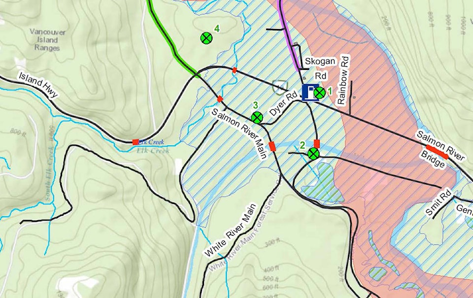
Eric Heel from McElhanney Engineering and Shaun Koopman, the Strathcona Regional District’s protective services coordinator, who made a presentation on the Salmon/White River National Disaster Mitigation study at the April 25 board meeting. The project is looking at flood risk in the Salmon River and White River near Sayward. The resulting study was completed with funding from the National Disaster Mitigation Program.
Flood plain modelling was undertaken in 1980 but did not extend to the Village of Sayward, as it only covered the valley immediately upstream from the village.
READ MORE: Sayward residents want cell service along highways
Heel said this work was down through a first stream of funding, which covers the assessment phase. Further funding streams focus on flood mapping, mitigation planning and non-structural or small-small structural mitigation projects.
“We look at potential areas of risk that are within the Salmon River floodplain,” Heel told the SRD board.
This process outlines factors to consider in an emergency such as transportation routes, hospitals and population centres.
“We start to identity, if there were to be a flood, who would be impacted,” he said.
Heel said they had a good turnout when they held a public event as part of the process last December.
“They brought quite a wealth of information,” Heel said, citing examples such as maps and historical photographs of flooding that happened from the 1950s up to the present day.
The community has experienced flooding over the years, and members of the public recalled incidents in 1975, 1990, 2008, 2011, 2014 and 2018.
“There’d been many flood events,” Heel said. “This is not something that’s lost into history. There’s many flood events in recent memory.”
Rather than the populated areas themselves, the biggest challenge for the Sayward region seems to be the transportation corridor, especially emergency access. In one case, some people had to be taken out by a helicopter.
“People had generally been safe, but they’d been cut off,” he said.
Heel also touched on old historical records dating back to the 19th century concerning flooding in the region, including one during which the high water mark of the river reached 30 feet above the previous high-water mark.
“It’s hard to really quantify what this flood would’ve looked like, but the numbers are quite staggering,” he said.
The study also included examining meteorological and seasonal factors for flooding. Specifically, this includes factors such as large rainfall events and snowfall melt, along with the potential of climate change to affect flood risk.
“It’s actually a bit of a mixed bag,” he said. “It’s difficult to say how climate change is going to impact flooding in Sayward.”
He expects flood events could be more frequent, though he could not say if they will be more severe, as snowfall pack is expected to decrease but precipitation will likely increase.
He also touched differentiated between “risk” and “hazard,” with the former referring to things that could be affected like populations or transportation corridors , while the latter examines things like water depth and speed. This phase of the program identified the risks while later streams would examine hazards. He said these “risks” mostly relate to previous industrial sites. As far as infrastructure, the main concerns are the evacuation routes out of town.
“We know that both these roads can be cut off during flood events,” he said, adding the sewage system is also a concern, though more from factors such as sea level rise or storm surges rather than rising river levels.
“The ocean presents risks just like the river does,” Heel said.
Area A Director Gerald Whalley, who represents the Sayward Valley, asked about the impacts of two major dikes built by the highway, especially since the road has been elevated.
He said in the 1975 flood, which he described as the last large-scale flood, the water freely flowed over the roads for hundreds of metres on each side.
Heel responded the next stream would focus on this kind of detail.
The next step is for the SRD to apply for the second stream of funding to continue the planning process. Koopman clarified the federal government program was worth almost $250 million last year, of which the SRD was awarded a grant of $71,000 for this study.