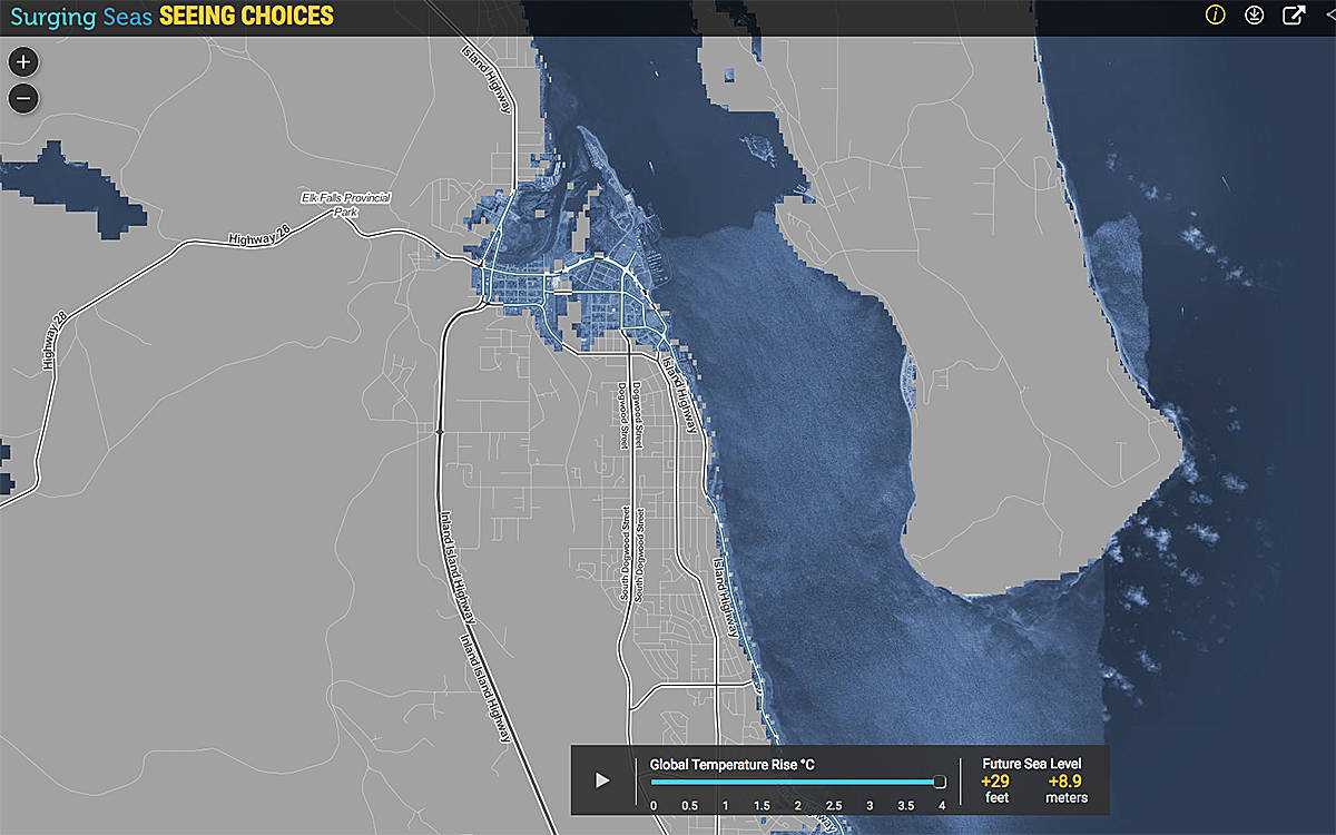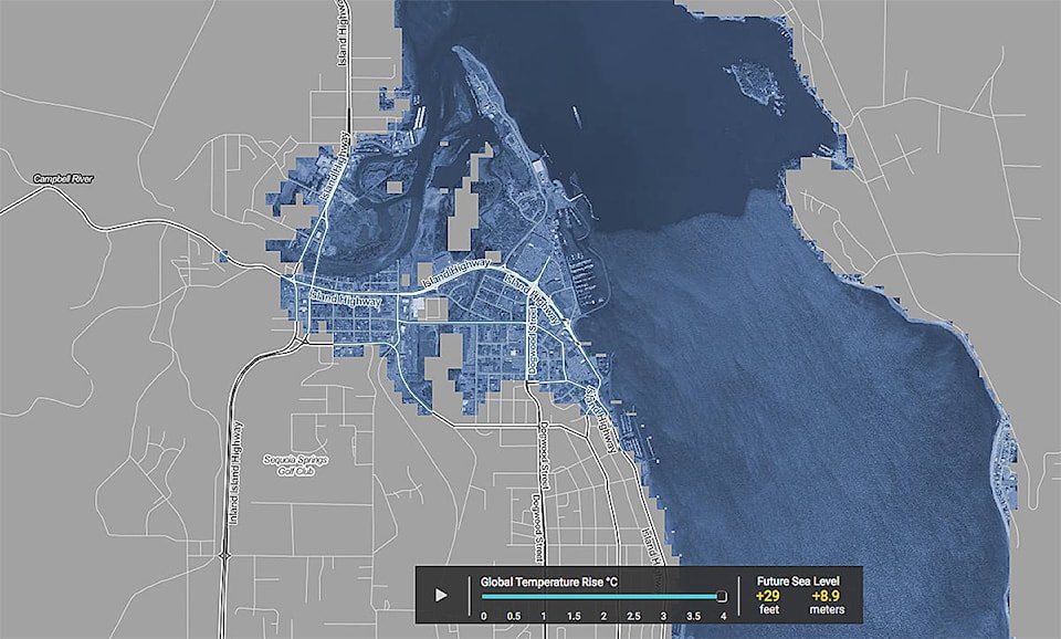
Campbell River will lose its downtown to sea level rise by the year 2100 if global temperatures were to rise 4°C, a map created by the organization Climate Central shows.
On Nov. 1, Climate Central launched its first animated map, Seeing Choices, which allows viewers to see the long-term sea levels locked in by different amounts of carbon pollution, contrasting scenarios of 0°C through 4°C of global warming.
At the maximum temperature rise of 4°C, the sea level on the B.C. coast would rise 29 feet, the map shows. That would see Campbell River’s downtown flood plain disappear under water with a few higher spots remaining as islands. This includes everything north of the hill dropping into downtown from the Dogwood ridge to the rising land north of Baikie Road and west of Spring Road in North Campbell River – essentially the traditional delta of the Campbell River.
If it were to rise one degree, the sea level would rise seven feet and flood the portions of downtown Campbell River that comprise the area east of the Island Highway as well as low lying spots between 16th Ave. and Highway 19a as it bends west towards Campbellton. The Tyee Spit would also be mostly underwater at one degree, the map shows.
Climate Central is “an independent organization of leading scientists and journalists researching and reporting the facts about our changing climate and its impact on the public.”
Climate Central says, “Based on recent scientific research, this global interactive tool builds upon our prior work and aims to focus attention on the urgency of moving away from fossil fuels to protect the stability of the world’s climate. Every fraction of a degree of global warming sets in motion sea level rise that will profoundly threaten coastal cities across the world. Every fraction of a degree prevented will save some.”
Climate Central adds, “If we emit enough greenhouse gases to heat the planet by 4°C—continuing the current path of unchecked pollution—we could drown coastal cities worldwide. If we make a rapid transition to a global clean energy economy and achieve the main goal of the Paris Agreement, limiting warming to 2°C, some cities will be saved. If we go faster and further to achieve the most ambitious Paris goal, 1.5°C, the outlook improves dramatically. Still, it is sobering to map the challenges following after 1°C of warming, a level we have just passed.”
The City of Campbell River is concerned about the impact of sea level rise on Campbell River. In December 2016, city council put improvements to Robert Ostler Park because they didn’t take into account the impact of sea level rise.
See: Ostler Park work put on hold
At that time, council said it will also consider the bigger picture of how to protect city infrastructure along the entire length of the city’s waterfront.
“An important step in the city’s asset maintenance process will involve reviewing the scheduled replacement plans for critical infrastructure that may be affected by sea level rise to ensure that we select locations and alignments that minimize risk,” Ron Neufeld, the city’s deputy manager and general manager of operations, said at the time. “For example, over the long-term, sewer and water lines that are currently buried on the water side of the highway may be relocated farther inland to provide better protection and access.”
Downtown Campbell River is recognized as a low-lying area at risk to flooding, if, for example, the John Hart Dam were to collapse due to an earthquake. The city has recognized that the No. 1 Fire Hall should be relocated at some point.
See: Plans for replacement of fire hall to go ahead in 2017
Climate Central says their map is meant to provide a picture of post-2100 sea level rise in order to inform dialogue about the issue and is not meant as a planning tool or as a predictor for any precise location.