The November 2020 landslide in Bute Inlet may have been an ecological disaster, but it also provided scientists with a chance to learn about this kind of landslide in real time and figure out how to prepare for a similar event in the future.
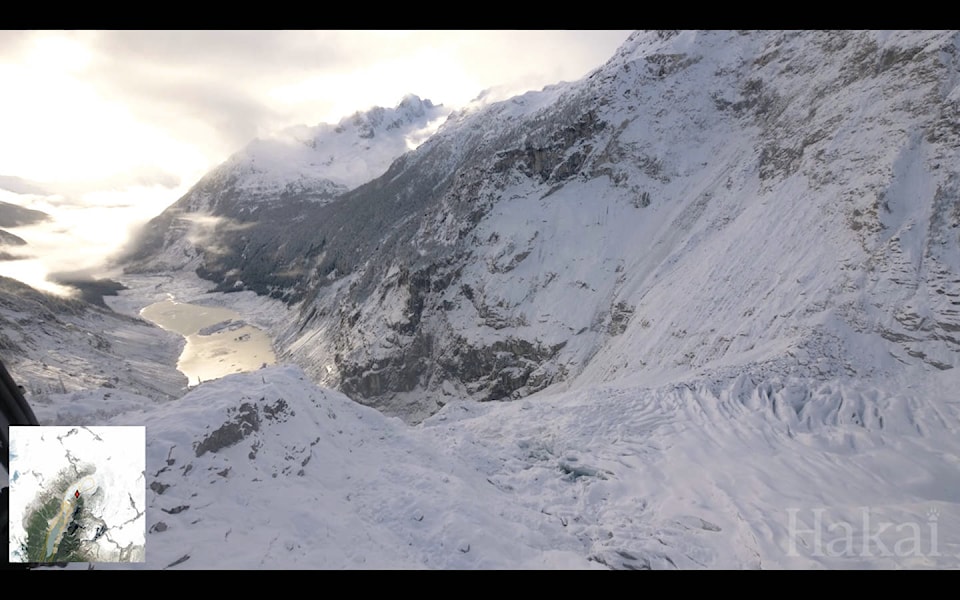
The landslide occurred above a Elliot Lake, a glacial lake near the inlet on Nov. 28. The falling rock and snow sent a 100-foot wave across the lake, bursting the banks and sending water cascading down the normally-calm Elliot Creek, which connects to the Southgate River and finally to the ocean below. The wave left a trail of destruction in its path, one that scientists have now been able to photograph extensively thanks to a helicopter flyover and a new 51-minute video documenting every centimetre of the area.
“We took up that charge, got our media team on board the helicopter with the doors off to collect the best images they could from icefield to ocean,” said Ian Giesbrecht, a researcher with the Quadra Island-based Hakai Institute who has been working in Bute Inlet for years. “That series of images should be valuable for both researchers and people doing stewardship to map out exactly what each piece of the landscape looks like, figure out where the hazards and sensitivities are, and figure out their next steps.”
Giesbrecht was already going to head up to the area to collect a water sample in November when his task changed.
“It just so happened that we were heading up there that week to collect a river water sample, when we heard about the Elliot Creek slide and offered to fly over and take a look at things,” said researcher Ian Giesbrecht. “It kind of unfolded from there that we find ourselves in a position to be able to offer up our existing data and some of our scientific capacity in service of the work that needs to be done to steward that location.”
“It’s a remarkably large area of destroyed riparian area ecosystem that will be in a state of change for many years to come. One of the interesting things from my perspective will be to track that change,” he added. “While there was a huge catastrophic event in late November that caused immediate damage and change, we’ve been monitoring it ever since then and we can see that there’s an ongoing effect to the river ecosystem and that’s also leading to an ongoing effect on the inlet waters.”
Giesbrecht and his team are taking advantage of the situation and getting a good look at the system post-slide before the spring thaw brings more water to the area and changes the new river channel.
“We would expect a bunch of new change to take place this spring as the snow melts and a lot of new water starts moving through the system, reworking and moving that sediment around, sending it downstream,” he said. “What we do know from our helicopter flight just last week is that the plume of sediment from the Southgate River is highly visible still entering at the head of Bute Inlet.”
That sediment plume has increased the turbidity of the water to 32 times the normal level.
“These are very high levels and quite exceptional at this time of year,” he explained. “It creates stress for the fish that are in the water and it affects habitat for fish when the fine sediment settles out in the river. It can bury the eggs and the spawning gravels.”
Scientists are taking advantage of the event to study the potential long-term effects of an event like this. A group of researchers from England are planning to work with Hakai scientists to study the amount of carbon that has been buried in the inlet by the slide.
“That’s an exciting piece of science that will come out of this unfortunate event and will allow us to better understand how these kinds of events might change coastal carbon cycling in the future in other places where they might occur,” he said.
The land is in the traditional territory of the Homalco First Nation, who have been working with the Quadra Island-based Hakai Institute to do research on the area for years. That research helps inform stewardship planning for the area, as well as do comparisons to other inlets and fjords in the coastal region.
“The type of watershed that we have in the Southgate River is actually fairly widespread on the coast,” Giesbrecht said. “Those places need to be looked at for the potential to have more of these events in the future.”
That information can be used to help communities like the Homalco First Nation plan for the future and to ensure the safety of everyone operating on their land.
Researchers are now waiting for LIDAR data to be compiled and translated into a usable format like a map. That will help them understand the factors that caused the slide, as well as identify safety concerns due to ground instability.
“I think everybody is eager to get boots on the ground while also taking the appropriate precautions to know that that can be done in a safe way,” he said. “In this disaster there is perhaps a silver lining in the opportunity for learning and applying that knowledge to other events that might happen in other places in the future so at least we can try and learn all we can from this and equip ourselves and share that knowledge.
“It’s quite a remarkable thing to be able to visually track every inch from top to bottom and how that landscape has been altered at this point in time so that we can do it again in the future so we can track as it continues to change.”
See the full 51-minute video of the area on the Hakai Institute website.
RELATED: Quadra Island-based research station investigates Bute Inlet slide
100-metre wave causes massive washout in Bute Inlet
marc.kitteringham@campbellrivermirror.com
Like us on Facebook and follow us on Twitter