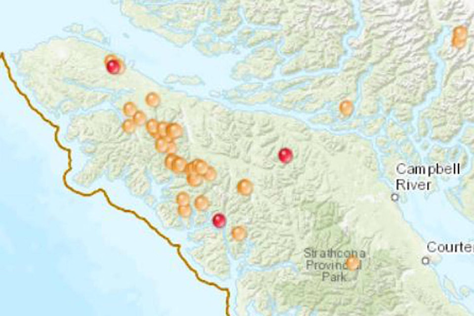
More than 35 wildfires were burning on the North Island by Tuesday morning, while smoky conditions meant that an air quality advisory remained in place for Campbell River and other communities.
Lightning storms sparked a cluster of wildfires on Saturday, but some didn’t ignite until temperatures rose the following day, said Dorthe Jacobsen, a spokesperson for the Coastal Fire Centre.
“When the weather warms up, they pop up as full fires,” said Jacobsen, adding that fires extinguished during the weekend were quickly replaced by new ones. There were 38 fires burning north of Highway 28 by Tuesday morning, she said.
READ MORE: Lightning sparks more than 30 fires on Vancouver Island
None of the fires posed an immediate threat to anyone’s home or business, said Jacobsen. But she noted that one small fire was burning just outside Zeballos, a tiny logging village located about 2.5 hours from Campbell River. Jacobsen said the fire was on “very steep terrain” making it inaccessible to firefighters.
“We’re currently out there trying to figure out how to fight that fire,” she said.
Will we got hit with lighting on Saturday morning had a fire start on the east side of the Village. Forest service kept looking at from the air, now we have a working fire. Forest service Will be in at first light from the air too hit the fire. Upper road to downtown closed.
— Zeballos Emergency (@zebepc1) August 14, 2018
A larger fire at Pinder Creek also flared up near the only road to Zeballos. Jacobsen said on Tuesday that the fire had grown to 40 hectares in size, and that it was “threatening the road.” There were 13 firefighters at the scene on Tuesday, she said.
An eight-hectare fire at Head Bay was also burning close to an access road for the village of Tahsis. But that fire had been 75 per cent contained by Tuesday morning, and 10 firefighters were on the scene, said Jacobsen.
The fire closest to Campbell River was at Buttle Lake, in Strathcona Provincial Park. Like most of this weekend’s fires, however, it was very small, measuring a fraction of a hectare.
There was also a 25-hectare fire at Vernon Lake and another measuring 15 hectares at Kaypit Lake. Jacobsen said that 10 firefighters were at Kaypit but couldn’t confirm whether any resources had been deployed at Vernon Lake.
She noted that resources were being deployed fluidly, with crews and aircraft moving from site to site throughout the day.
“It’s very dynamic,” she said.
Meanwhile, the largest blazes on the North Island were dwarfed by those happening elsewhere in the province, including one at Nanaimo Lakes that was estimated at 182 hectares. That fire, discovered on Aug. 5, is suspected to be person-caused, according to the BC Wildfire Service.
As wildfires continued to burn, the Coastal Fire Centre urged caution, noting that temperatures becoming hot and dry again, despite a bit of rain this weekend.
“We’re very concerned about person-caused fires because they take resources away from these naturally occurring lightning fires,” said Jacobsen. “We’re begging the public to please respect the open fire prohibitions in place.”
Wildfires created smoky conditions in the region, leading to a special air quality statement for Campbell River, the Comox Valley, Duncan, Nanaimo and Parksville. That statement, issued Sunday, remained in effect by Tuesday morning.
Smoke created a haze over Campbell River, and the sun appeared as a reddish glow behind the smoky veil at times. The smoke flowed mainly from the B.C. Interior, but also from Washington State, said Earle Plain, air quality meteorologist at the provincial environment ministry.
A pair of major fires on the B.C.-Washington border, at Snowy Mountain, were generating some of the smoke, he said, while fires on the Island were “adding local source smoke to the mix.”
Environmental and health authorities issued statements reminding the public that exposure to wildfire smoke can be harmful, especially for the elderly, infants and children, and sensitive individuals or those with pre-existing health conditions.
Amid the smoke, daily average levels of airborne particulate matter spiked at the Elk Falls Dogwood station, with PM2.5 levels reaching 42.7 micrograms per cubic metre on Monday night.
PM2.5 refers to fine particles that can damage the heart and lungs. The province considers PM2.5 concentrations of 25 micrograms per cubic metre to be an “acceptable limit.”
A map produced by the B.C. environment ministry indicated that concentrations of the fine particulate matter had exceeded their limit in all monitored communities in B.C. as far north as Prince George by Tuesday morning.