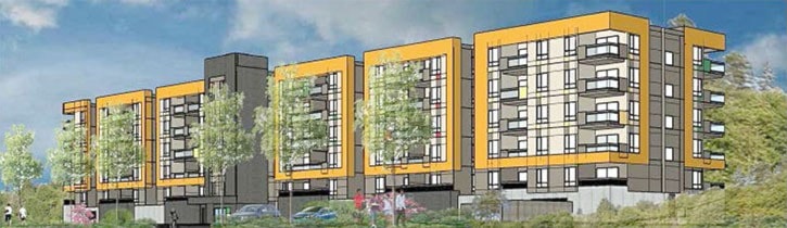
A proposed 97-unit apartment building that some residents fear could trigger a catastrophic mudslide is one step closer to reality.
At its Monday meeting, city council gave third reading to a rezone of the vacant lot at 1430 South Island Highway from its existing Commercial Five designation to Residential Multiple Three in order to facilitate the construction of a rental apartment.
Coun. Larry Samson said he was pleased to see the property taken out of the commercial zone which he believes would have allowed for a development that would have a greater impact on the slope that rises up from the back of the property.
“The residential is a smaller footprint, it has much less impact on the bank,” Samson said.
The development – which is slated to be built on property just south of the Rockland Road and Island Highway intersection – has caused a stir among residents living on the ridge above the property.
At a public hearing two weeks ago, four people spoke against the property owner’s rezoning application.
All speakers voiced concerns about the stability of the slope, including Rolly and Lynn Hilton who lived through mudslides in both 1980 and 1998 triggered by excavation activity in the area. Lynn Hilton told council that the slide in 1998 took out a “substantial portion” of their property as it roared into the back of the former Marina Inn and rolled into a room on the lower floor.
Patrick Rowe, who also lives up above the ridge, said he worries this most recent development proposal could trigger another mudslide.
“Should a slide occur in the depiction of the current proposal, then the rear-facing units – most likely more than one unit, of the bottom two levels inhabited by humans – could easily be involved, leading to severe injury and even death,” he said. “In how many victims?”
Chris Osborne, senior city planner, said he can understand those fears but in a written report to council, made assurances that no development will be allowed to go ahead without first assessing the slope’s stability.
”These concerns are legitimate; however, geotechnical considerations are dealt with as part of both the development permit and building permit processes,” Osborne wrote. “The Hazardous Conditions (steep slope) SOCP (Sustainable Official Community Plan) development permit requirements are triggered by the proposed development, which includes consideration of stormwater drainage and vegetation removal/retention as part of bank stability assessment. This must be addressed within a geotechnical report signed by a professional engineer.”
Osborne pointed out that issues related to slope stability and other concerns relayed by the neighbours surrounding sight lines and the proposed height of the building, are meant to be dealt with during the development permit application process, which comes after the rezoning phase that council is just now dealing with. That means that although council has passed third reading of the rezoning bylaw, the development itself will not necessarily be approved exactly as proposed.
“Allowing and prohibiting different uses within a parcel through a zoning bylaw offers no guarantee that the parcel can be practically or economically developed, or that development and building permits will necessarily be granted,” Osborne said.
Osborne did acknowledge, though, that the developers have already submitted a major development permit to the city in conjunction with the rezoning application. As part of that development permit, city staff is awaiting submission of a geotechnical report which will be assessed by the city’s planning department.
“Staff’s review will include geotechnical assessment of the steep slope, impact of the proposed buildings on view corridors, building mass, parking, and conditions pertaining to the nearby eagle nest trees, among other form and character considerations,” Osborne said. “This major development permit will be considered by council should the subject property be rezoned.”
Final adoption of the rezoning application will likely be considered by council at its next meeting, on March 27.
If adoption does go through, city staff has applied a condition to the rezoning.
The applicants will be required to secure a 4.9 metre strip of their property, adjacent to the Island Highway, to be dedicated as public roadway and consolidated into the existing road right-of-way. This area is required to facilitate the eventual upgrading of the highway at this location by bringing the right-of-way up to the desired width.
Staff also wanted the developers to build a temporary sidewalk from their property to roughly the intersection of Rockland and the highway where the sidewalk currently ends. Staff said the sidewalk wouldfill a temporary gap for pedestrians trying to access nearby transit stops, until that area of the highway can be upgraded.
Council, however, shot that down.
“I certainly appreciate staff’s intention in suggesting the proponent have to put in a temporary sidewalk to the lift station…but I think it’s unreasonable to expect the proponent to do work on property that’s not theirs,” Mayor Andy Adams said.
Coun. Charlie Cornfield agreed.
“I don’t think it’s too fair to ask a developer to build off their property lines,” said Cornfield, who added that there is a transit stop heading south right in front of the property and a pedestrian-activated light at the Rockland Road crosswalk for easy access to the transit stop going northbound.
Cornfield said he’s confident that the other issues will be sorted out during the development and building permit stage.
“I think the development permit process will take care of the other issues of concern for me, so I will support (the rezoning),” Cornfield said.