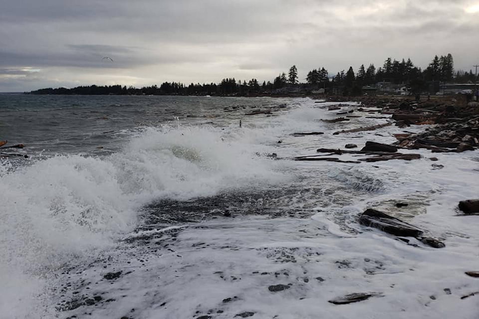
Waves seem to reach further inland as they beat against the coast these days, says Campbell River resident John Lewis.
“I’ve watched it over 50 years, and it is happening,” said Lewis, a sea captain who is preparing to build a home on a beachside lot by the Seawalk.
“We want to build a modest, energy-efficient home here that will hopefully stand the test of time,” Lewis said as he stood by the vacant lot, formerly the site of a home belonging to his parents. Over the past few decades, the family installed two layers of rock armour to keep the ocean at bay.
“We started getting everything from bark to larger pieces of material and the odd splash,” Lewis said, noting that the area is exposed to southeast winds from across the Strait of Georgia, creating big waves. “That’s the challenge that Campbell River has.”
Lewis was among the local residents who attended the latest public meeting about sea level rise hosted by the City of Campbell River.
More than 40 people gathered for the May 30 event at the Maritime Heritage Centre, where they discussed a new report published by the city as it prepares to deal with rising seas.
Measures recommended in the report include raising the level of downtown streets and buildings, building offshore breakwaters and converting some coastal homes into parkland.
The city is asking members of the public to provide feedback about the recommendations through an online survey by June 15. (Community members can also submit paper copies that were distributed at the workshop, and which are still available at city hall.)
Sea rise speeding up
The province has recommended planning for a sea level rise of a half-metre by 2050, one metre by 2100 and two metres by 2200.
But actual sea level increases will depend on the volume of greenhouse gases released by humans into the atmosphere, explained Grant Lamont, a coastal engineer with Northwest Hydraulic Consultants, a firm hired by the city to study ocean dynamics.
The projections might be conservative, he said, noting that rapid polar ice loss during the second half of the century and thermal expansion of the oceans may result in a two-metre rise by 2100.
He pointed to the State of California and New York City as coastal jurisdictions contemplating a faster, two-metre rise.
“They’re saying that for high-emissions scenarios… that for planning levels you should be considering two metres of sea level rise for the year 2100,” Lamont said.
Increases in sea level beyond the one-metre mark will likely come at a faster pace, he said, meaning that future generations will have to deal with change in a much shorter period of time.
Some critics of the city’s policy on sea level rise have pointed to data showing a downward trend in sea levels for Campbell River.
Data from the National Oceanic and Atmospheric Administration (NOAA), an American scientific agency, indicates a sea level decline of 1.64 mm per year from 1965 to 2016 in Campbell River.
Lamont acknowledged that data and said it’s explained primarily by a geological uplift of the land in the Campbell River area. But the sea is now rising faster than the land, he said.
In Campbell River and other cities, that will likely mean retreating from certain coastal areas.
“With sea level rise on a typical shoreline, what we’re going to get is… a landward retreat,” he said.
Downtown
Possible measures for the downtown area include breakwater extensions and a raised seaside walkway around the downtown area, according to the new 23-page report, which is available on the city’s website.
At the ferry terminal, a temporary barrier could be installed for flood protection when driving lanes to the ferry are closed during major storm events.
The report suggests that buildings, roads and utilities could be raised or rebuilt to protect against high water levels combined with storm surges.
That work would take place over time, when buildings and infrastructure are already being replaced, said David Reid, an architect working with the city on sea-rise planning.
“We’re suggesting to raise when you rebuild,” he said.
The report notes that habitable parts of buildings should be high enough to account not only for high tides and storm surges, but also wave effects and unknowns including “a more rapid sea level rise than anticipated.”
Changes recommended for sea-level rise in downtown Campbell River: raised buildings, roads and utilities; extensions to breakwaters; raised seaside walkway; temporary flood barrier at ferry terminal; and the installation of pump stations and underground stormwater tanks. pic.twitter.com/DrSMpVgOyD
— David Gordon Koch (@davidgordonkoch) June 11, 2019
Other measures could include installing underground stormwater tanks and pump stations, but their construction should be “delayed as long as practical,” to allow for funding options to be explored, according to the recommendations.
Willow Point
In Willow Point, which is exposed to stormy conditions from the waters south of Quadra Island, the city could build offshore breakwaters at locations including Frank James Park.
Other measures for the area could include “beach nourishment,” meaning the placement of gravel and sand along the coastline, to reduce the impact of storms.
Some homes are likely to be at risk, generally older cottage-type structures built relatively close to sea level.
“There are several of those that are at risk of inundation,” Reid said.
The Island Highway appears to be high enough, at least for a one-metre rise in sea level. But further increases in sea level will require the thoroughfare to be raised.
“There’s a longer-term issue, but for a metre of sea level rise, the road appears to be okay,” Reid said.
The report suggests the city buy properties “on a willing-seller basis” along the more exposed sections of the coast and convert them into parkland.
These areas could potentially have “narrow openings to the sea” among rock armouring to create sheltered beaches or marsh environments.
Sea-level rise preparation in Willow Point may include the construction of offshore rock breakwaters, "beach nourishment," and the city buying up homes in exposed areas and converting them to parkland. pic.twitter.com/isjdQcFCwa
— David Gordon Koch (@davidgordonkoch) June 11, 2019
The report adds that towards the end of the century, or during reconstruction, it would be appropriate to consider raising the Seawalk and pump stations.
READ MORE: ‘Climate change in action:’ Scientist says fires in Alberta linked to climate change
READ MORE: Seawater could cover downtown Campbell River due to climate change-fueled floods
Flood barriers might also be necessary along the lower parts of Simms Creek and Willow Creek during coastal storms that coincide with high tides and inland rainfall events, the report adds.
Sequoia Park
In the Sequoia Park area, extending from the Maritime Heritage Centre to Evergreen Road, the report suggests the construction of raised “pocket beaches” and offshore rock headlands.
This would help reduce the risk of slope failure due to erosion, though it wouldn’t eliminate that risk, according to the report.
The design would create recreational areas for the public, and may also enhance the foreshore ecology. But in some areas, if the city can’t gain the riparian rights from waterfront property owners, “existing or eroding beach would remain, restricting public access along the shoreline,” the report says. “In these locations, waterfront land owners would be responsible for shoreline protection.”
In the Sequoia Park area, the report recommends creating "pocket beaches" formed by offshore headlands, to address erosion linked to sea-level rise. The risk of steep slope failure would be reduced "but not eliminated." pic.twitter.com/oEyfbQ1Vva
— David Gordon Koch (@davidgordonkoch) June 11, 2019
Painter Barclay
The report notes that in the Painter Barclay area of North Campbell River, bluffs are at risk of erosion, which could threaten existing homes. The installation of improved “groynes,” low walls jutting into the sea, could reduce the impact of erosion caused by longshore currents. Other measures for the area could include beach nourishment.
In the Painter Barclay area of North Campbell River, improved âgroynesâ and beach nourishment could reduce erosion that would eat away at bluffs, threatening existing homes, the report says. pic.twitter.com/RF7jIQKfcT
— David Gordon Koch (@davidgordonkoch) June 11, 2019
The report suggest those measures could be privately-funded neighbourhood improvements. The city could provide certain services including design and applications for grants and approvals from senior levels of government.
Shared costs
That’s one example of the complexities of financing the potentially costly climate change adaptation work. The report proposes limiting the city’s role to technical support for the protection of private property – not capital funding, unless a “significant community benefit” is involved.
This plan would likely rely on shared financing through a “local improvement approach” that requires neighbourhood approval, the report says. Local improvement projects “would allow neighbourhoods to pool funds for capital works on the foreshore” and inland areas such as in downtown Campbell River.
Gradual reconstruction as buildings and infrastructure reach the end of their lifespan will be less costly than waiting for a catastrophic flood, Reid said.
“When we do renew things… it’s an opportune time to say ‘well, do we need to make it a little higher up?’”
Having recently visited Europe, he also noted large-scale student protests over climate change in Denmark.
“It’s a worldwide issue and it’s not going away.”
@davidgordonkoch
david.koch@campbellrivermirror.com
Like us on Facebook and follow us on Twitter