After years of consultations and studies, the Campbellton Neighbourhood Association (CNA) had a scaled-down version of what used to be their grand plan for the head of the Myrt Thompson Trail approved by council this week.
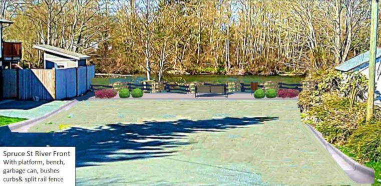
The “pocket park,” as it is being called, will be installed at the north end of Spruce Street, a couple of blocks up from their initial plan at the end of Maple Street, thanks to council’s willingness to have city staff maintain it upon its completion – along with a $15,000 grant from Fortis BC, which was then matched by the city.
The location was seen as a key component in the revitalization of the neighbourhood during a series of consultations dating back to 2014 alongside members of the Urban Planning Team from Vancouver Island University, who had already been working on a plan to rejuvenate the area for more than a year at that point.
The initial plan was to create a series of paths and viewing platforms for the area, as well as various river access points, but that’s something the CNA has scaled back on and will consider adding down the road.
“Never underestimate a group of dedicated volunteers with a vision,” Coun. Ron Kerr said upon reading the motion at Monday’s meeting to approve the park. “The CNA has had a vision with accessibility to the river as one of their priorities, and they’ve worked hard over the last few years and I want to thank all the volunteers who worked on it, as well as city staff for stepping up and working with them to get it over the finish line.
“It’s really exciting to finally see this happening.”
Coun. Charlie Cornfield says he, too, is glad the project will finally be going forward, but he also expressed disappointment that “access to the river” had been downscaled out of the current proposal.
“I guess I have some concerns, because I was looking forward to being able to access the river, especially on that side, which has not got any access points until you get down the Myrt Thompson (Trail) but the river is closed to fishing at that point,” Cornfield said.
City long range planning and sustainability manager Amber Zirnhelt confirmed that the initial plan, which contained the river access points and viewing platforms, “but they’ve decided to focus on a smaller scale project, but that’s not to say they won’t, in the future, be looking for additional opportunities to access the waterfront.”
Mayor Andy Adams said his main concern was a different type of “accessibility” after seeing that the overall surface of the park was to be “natural landscaping” such as rocks, gravel and wood chips.
“For those in wheelchairs or walkers, could there at least be concrete just getting to the bench?” Adams asked. “It would be nice if someone in a walker had access to the bench without going through gravel or wood chips.”
“I will certainly pass that concern on to the parks department,” Zirnhelt said. “I know their aim is to make this accessible, so the material leading to the bench and at the access points, their aim is for people of all activities to be able to access it.”